Zimbabwe
A nation of spectacular natural beauty, friendly people and rich culture, Zimbabwe’s status as one of Africa’s leading safari destinations was dampened for years by its political instability. But now that the country is transcending its strife and returning to a state of equilibrium, it is once again emerging as a vacation highlight of the continent.
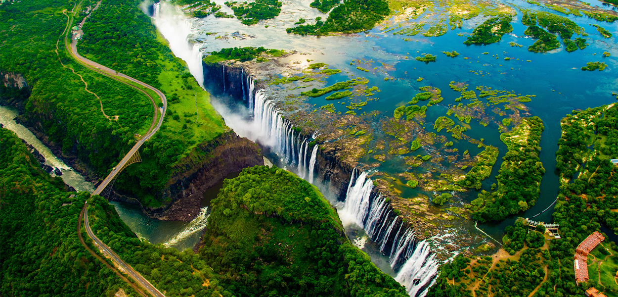
Victoria Falls – known to locals as ‘The Smoke That Thunders’ – is one of the seven natural wonders of the world and the sheer power of this massive body of water plunging into the Zambezi Gorge is awe-inspiring and unforgettable. Lake Kariba, with its game-rich shores and islands, is an idyllic safari spot featuring mind-blowing sunsets;
Hwange National Park is known for its huge herds of elephants; and a kayak trip down the Zambezi through the Mana Pools National Park will appeal to the intrepid traveller, providing close encounters with crocodiles, hippos and a host of other wildlife.
Zimbabwe lies almost entirely over 1,000 feet (300 metres) above sea level. Its principal physical feature is the broad ridge running 400 miles from southwest to northeast across the entire country, from Plumtree near the Botswana frontier through Gweru (formerly Gwelo) and Marondera (formerly Marandellas) to the Inyanga Mountains, which separate Zimbabwe from Mozambique. About 50 miles wide, this ridge ranges in altitude from 4,000 to 5,000 feet, until it eventually rises to 8,504 feet (2,592 metres) at Mount Inyangani, the highest point in Zimbabwe, in the eastern highlands.
This ridge is known as the Highveld and comprises about 25 percent of the country’s total area. On each side of this central spine, sloping down northward to the Zambezi River and southward to the Limpopo River, lies the wider plateau of the Middleveld, which, at an altitude between about 3,000 and 4,000 feet, makes up roughly 40 percent of Zimbabwe’s area.
Beyond this again and mostly in the south, where the Sabi, Lundi, and Nuanetsi rivers drain from the plateau into the Limpopo, lies the Lowveld, which constitutes approximately 23 percent of the country’s total area. The lowest point in Zimbabwe lies at an altitude of 660 feet near Dumela, where the Limpopo flows into Mozambique. There are no parts of Zimbabwe that can properly be called desert, although a sector northwest of Plumtree and a lengthy belt across the Lowveld in the south are severely arid.
Location
Southern Africa, between South Africa and Zambia
Geographic coordinates
20 00 S, 30 00 E
| Visa requirements | You need a passport, visa, return ticket, and adequate funds to cover your intended stay in order to enter Zimbabwe. If you are traveling to Zimbabwe for tourism, business, or transit, you may obtain a visa at the airports or other border ports-of-entry. |
|---|---|
| Languages spoken | Shona (official, most widely spoken) 80.9%, Ndebele (official, second most widely spoken) 11.5%, English (official, traditionally used for official business) 0.3%, 13 minority languages (official; includes Chewa, Chibarwe, Kalanga, Koisan, Nambya, Ndau, Shangani, sign language, Sotho, Tonga, Tswana, Venda, and Xhosa) 7%, other 0.3% (2022 est.) |
| Currency used | Zimbabwean Dollar |
| Area (km2) | 390,757 sq km |
| Country name | Zimbabwe |
